
Highlight
Buffalo Team Performs Rapid Assessment of Building Damage AFter the Haiti Earthquake
Building damage assessment following the Haiti Earthquake
Achievement/Results
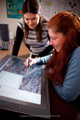
Professor Chris Renschler (IGERT Faculty) directed a group of students at the University at Buffalo in an effort to provide a rapid large-scale damage assessment following the Haiti Earthquake. The magnitude 7.0 earthquake occurred on January 12, 2010 and was responsible for over 200,000 deaths and much destruction in the Port-au-Prince region. Prof. Renschler’s group, which forms the Landscape-Based Environmental Systems Analysis and Modeling lab (LESAM) housed within the Geography Department, included Amy Frazier (IGERT trainee) and Suzanne Roussie (IGERT affiliate). Their work and that of other volunteers, completed around-the-clock in the weeks following the disaster, was important to relief efforts.
There was an urgent need to provide quick turnaround of results of accurately mapped locations of damaged buildings to personnel involved in relief and recovery on-the-ground in Haiti. The data gathered by the group supported initial requirements in order for the Post Disaster Needs Assessment to be undertaken by the United Nations (UN), European Commission (EC), and World Bank. UB was participating in a project that was initiated by ImageCat Ltd, an independent research and development organization in the field of disaster response, assessment and recovery. ImageCat collects data in the immediate aftermath of a disaster using satellites, helicopters, aircraft, and vehicles on the ground. Images are interpreted by remote sensing analysts and engineers, and the information is provided to interested parties for aid, insurance, recovery, and reconstruction.
In the wake of the Haiti disaster, ImageCat was contracted by the World Bank to perform damage assessment based on pre- and post-event high-resolution imagery and make the results freely available to the public. Due to the pressing need for a large-scale effort to rapidly assess the imagery for damages, ImageCat coordinated the Global Earth Observation-Catastrophe Assessment Network (GEO-CAN). GEO-CAN, the first world-wide network group assembled of its kind, was tasked with the mission to provide a rapid response to the damage by generating maps of collapsed and heavily damaged buildings using pre- and post-event imagery. Prof. Renschler and his team joined more than 700 volunteer scientist and researchers from 161 organizations in 23 countries. Their findings were ultimately used by the World Bank to measure the cost of the event and to inform the reconstruction program.
Of the GEO-CAN effort, Saroj K. Jha, Manager and Head of the Global Facility for Disaster Reduction and Recovery (GFDRR) Secretariat said:
“GEO-CAN represents the overwhelming response from the international academic community to assist in the damage assessment and reconstruction of Haiti. We are very pleased to work with ImageCat in leveraging the expertise of engineers and scientists throughout the world to quickly and accurately assess damage to buildings and critical infrastructure in Port-au-Prince and other affected areas.”
The interdisciplinary work completed by the LESAM team involved remote sensing analysis, structural engineering interpretation, and GIS mapping. A major challenge to the project was indentifying qualified volunteers worldwide with expertise in GIS and remote sensing along with working knowledge of structural engineering and extreme events to correctly and accurately identify and assess building damages. Renschler’s LESAM group has long been involved in collaborations with UB’s Multidisciplinary Center for Earthquake Engineering Research (MCEER) and its GeoHazards Center. As a cross-disciplinary research group in remote sensing, GIS, engineering and geo-hazards, the LESAM group was well-suited to perform the work. The group was an integral part of the international team.
The overall effort took place in two phases carried out in the weeks following the earthquake. Phase I was an initial rapid assessment to determine the general extent of damages in the earthquake zone. During this stage, the group located and marked collapsed and heavily damaged buildings using imagery served through Google Earth. Each volunteer was assigned a 500m2 grid cell and was tasked with flagging all buildings meeting criteria established by the structural engineering community for collapsed or heavily damaged buildings. Once a grid cell was completed, results were sent to ImageCat to be compiled, and a new grid assigned. In this manner, approximately 134 km2 were assessed within 48 hours, identifying more than 5,000 damaged or collapsed structures.
Based on the extent of the damages uncovered during the first phase, Phase II was launched to map the actual location and footprints of the damaged and collapsed buildings. The area was expanded to 346 km2 by including additional areas adjacent to Port-au-Prince to north, east, and southwest. A checkin/checkout system for grid cells was once again used, to avoid duplication of effort; more than 1,384 grid cells were assessed and more than 10,000 buildings mapped, all within 96 hours. Ongoing work is focused on estimating square footage of damages for reconstruction.
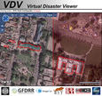
All imagery collected by ImageCat and results of the GEO-CAN mapping and analysis effort were served out to the public via the Virtual Disaster Viewer (VDV).
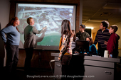
The interdisciplinary focus of the LESAM group, which includes training in remote sensing, GIS, engineering and geo-hazards, along with their willingness to volunteer weekends for the rapid assessment efforts were vital to the GEO-CAN mapping efforts. The group, along with the National Center for Geographic Information and Analysis, was recognized as a project partner. The efforts of Prof. Renschler and his lab were also highlighted in various local news reports and newspapers: http://www.youtube.com/watch?v=BhmoUTj5knQ.
Address Goals
The project provided the students and professors involved with an opportunity to have a real and broader impact on society, perhaps to save lives. Skills and techniques learned in courses or in basic research were brought to bear on response to a natural disaster with extreme casualty rates. The project brought science and engineering to the public through television and YouTube coverage, and showed the world that US technology and US scientists and engineers can contribute to solving real problems resulting from extreme events.