

Highlight
Embankment Health Monitoring
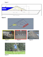
Embankment Health Monitoring Pictures
Achievement/Results
The Colorado School of Mines SmartGeo IGERT SmartDam Team’s research goals are to develop technology needed to advance traditional monitoring methods for Loading…earth dams and levees into intelligent adaptable systems. Intelligent earth dams and levee systems include continuous ‘health’ monitoring and assessment, with means to adapt to improve performance and/or reliability. Using continuous and wireless sensing and monitoring, intelligent earth dams and levees will assess early onset of internal erosion and other damage due to aging, continued, and extreme loading, and will advance 4D (space and time) monitoring systems that fuse together geophysical, geotechnical and sensing data.
This year, trainees deployed wired time lapse continuous monitoring on a full-scale levee test and experimented with side-by-side wired/wireless sensors with a culminating project in the Netherlands. IGERT trainees Ben Lowry, Minal Parekh, Jacob Grasmick, and Justin Rittgers collaborated with US and international partners to participate in an internal erosion test on a full-scale test levee in the Netherlands in September 2012. The team of students installed self potential (SP), passive seismic, and lidar and radar remote sensing techniques to continuously monitor a week-long test. During the test, the team collected baseline conditions prior to hydraulic loading and continuously monitored the embankment as internal erosion initiated and continued within the sand foundation, as evidenced by sand boil formation and grown, and as the clay embankment cracked and deformed. (Figures 1 – 5)
Address Goals
This project accomplishes both primary and secondary goals of the IGERT training program. While each technique on its own benefits from the research and testing, the IGERT collaboration makes joint analysis and monitoring possible, allowing for insight into how these methods would be conducted within actual monitoring context. Collaboration with agencies in the Netherlands fosters collaborative ties and seeds innovation in the field of infrastructure monitoring. Justin Rittgers and Marc Rubin continue to experiment with wired versus wireless sensors. In other words, we are trying to compare the relative performance of “traditional” wired acquisition of seismic and self-potential sensor data with our custom wireless sensor array. We briefly describe two preliminary tests and then summarize our custom, inexpensive, and easy to use wireless platform.
In the first the of experiments, we placed a geophone sensor in a field and recorded seismic vibration data using both a wired and wireless acquisition system. For a seismic source, a colleague placed a wooden block on the ground and pounded it using a sledge hammer (Figure 6). This process was repeated from many different distances, from a ten to about fifty meters. To reiterate, we collected seismic data from a single geophone using a commercially available wired system and our custom wireless device. Preliminary results are quite promising; our custom and inexpensive wireless device seems to work, at least qualitatively, as well as the commercially available and much more expensive wired system. Specifically, the seismic events captured by the wired system are clearly visible in the data collected by our custom wireless device. We plan to conduct more experiments and do quantitative analysis to better compare our custom wireless to existing wired seismic data acquisition. (Figure 7)
In the second set of experiments, we collected self potential electrode data from a test sand tank containing a subsurface electrical anomaly (Figure 8). The anomaly was a voltage potential that was caused by a metal pipe corroding in saturated sand. Much like before, we collected both wired (Figure 9) and wireless (Figure 10) data of the self-potential electrodes in the sand tank. The preliminary results show, qualitatively, that our custom wireless acquisition device is working quite well. Particularly, the electrical anomaly is clearly visible in both the wireless and wired SP results. We plan to scale up the tests and perform more quantitative analysis in the near future. The advanced instrumentation being developed by the SmartGeo Smart Dam research team could lead to early detection to inform decisions that could reduce the likelihood of damage and life loss. The instrumentation aims both to sense and to monitor ‘health’ of levees and dams in order to assess early onset of internal erosion and other damage due to aging or extreme loading.
These experimental tools will advance the frontiers of knowledge of 4D (space and time) monitoring systems by fusing together geophysical, geotechnical, and remote sensing technologies. Only through interdisciplinary technology transfer, and through understanding policy roadblocks and how to work with governmental agencies, will implementation of these technologies be possible.
